School nearby Ecole Om Azza
Morocco
School nearby Ecole Om Azza
Ecole Om Azza
P4025, Centre Commune Om Azza, Skhirat-Témara, MA Marruecos
contacts phone
:
+212
Latitude:
33.8803673
, Longitude:
-6.7856241
larger map & directions
read more
nearest School
5.86 km
Academy Royale
Avenue Mohamed VI, Rabat
School
read more
11.477 km
Madariss Assalam _ مدارس السلام
Rabat
School
read more
11.744 km
لالة عائشة الثانوية الإعدادية
Rabat
School
read more
11.744 km
Lycée Agricole
Rabat
School
read more
11.804 km
KINDY CODE SCHOOL
38 Rue Attoute secteur 10 Hay Riad, Rabat
School
read more
12.003 km
School Mohammed Ben Ahmed Chmaou
Rabat
School
read more
12.292 km
School Group Le Litoral Prive
Rue Chtouka, Rabat
School
read more
12.324 km
Collègue 11 Janvier
Temara
School
read more
12.401 km
École Outman Bno Affane
Temara
School
read more
12.513 km
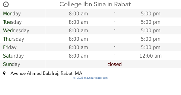
College Ibn Sina
Avenue Ahmed Balafrej, Rabat
School
read more
13.665 km
School Mokhtar Jazoulit
Avenue Al Fath, Rabat
School
read more
14.098 km
ILCS
Avenue Al Atlas, Rabat
School
read more
14.31 km
Smart Way
N° 6, Im 66, Avenue Fal Ould Oumeir, Rabat
School
read more
14.422 km
Sanabil El Fath School
Avenue Al Massira, Rabat
School
read more
14.465 km
Esint
kouass, Avenue Al Massira, Rabat
School
read more
14.474 km
école Al Maghrib Al Arabi
Rabat
School
read more
14.584 km
G.s Az
Temara
School
read more
14.615 km
Afaak Al Ailm
Boulevard Amina Bint Wahb, Témara
School
read more
14.665 km
School Scientific Galiléo
Rabat
School
read more
14.88 km
Soutien Scolaire Annour
Rabat
School
read more
15.073 km
Ea-School
11 Rue Dayat Aoua, Rabat
School
read more
15.118 km
Establishment Adam Education
Rabat
School
read more
15.144 km
Institute Al Manahil
Avenue Moustapha Assayeh, Rabat
School
read more
15.173 km
DGSN HQ beach
Rabat
School
read more
15.496 km
Nursery Mother Coccinelle De Valentina
Temara
School
read more
📑
all categories
Accounting
Administrative area level 1
Administrative area level 2
Airport
Amusement park
Aquarium
Art gallery
Atm
Bakery
Bank
Bar
Beauty salon
Bicycle store
Book store
Bus station
Cafe
Campground
Car dealer
Car rental
Car repair
Car wash
Cemetery
Church
City hall
Clothing store
Colloquial area
Convenience store
Courthouse
Dentist
Department store
Doctor
Electrician
Electronics store
Embassy
Establishment
Finance
Fire station
Florist
Food
Funeral home
Furniture store
Gas station
General contractor
Grocery or supermarket
Gym
Hair care
Hardware store
Health
Home goods store
Hospital
Insurance agency
Jewelry store
Laundry
Lawyer
Library
Light rail station
Liquor store
Local government office
Locality
Locksmith
Lodging
Meal delivery
Meal takeaway
Mosque
Movie rental
Movie theater
Moving company
Museum
Natural feature
Neighborhood
Night club
Painter
Park
Parking
Pet store
Pharmacy
Physiotherapist
Place of worship
Plumber
Point of interest
Police
Post office
Premise
Real estate agency
Restaurant
Roofing contractor
Route
Rv park, camping
School
Shoe store
Shopping mall
Spa
Stadium
Storage
Store
Supermarket
Synagogue
Taxi stand
Train station
Travel agency
University
Veterinary care
Zoo
sublocality level 1
↑