School nearby Smart Way
Morocco
School nearby Smart Way
Smart Way
Avenue Fal Ould Oumeir, Rabat, MA Morocco
contacts phone
:
+212 660-773435
Latitude:
33.9978788
, Longitude:
-6.84891
larger map & directions
read more
nearest School
28 m
Smart Way Rabat
Avenue Fal Ould Oumeir, Rabat
School
read more
68 m
Ecole Technique des Sciences d'Informatique Appliquées et Management Privée- ESIAM
Avenue de France, Rabat
School
read more
79 m
Institut ITECH BTP
66 N°11, Rue Oued Moulouya, Rabat
School
read more
95 m
Bridge Value
Bridge Value, 3éme étage, Imm 45, Angle Avenue de France et rue Toubkal., Rabat
School
read more
163 m
École Esiaha - مدرسة سياحة
Imm 39, Appt 4, Rue Jabal Tazeka, Rabat
School
read more
202 m
Educall
Immeuble 24, Appt 8, 3ème étage, Avenue de France, Rabat
School
read more
233 m
ILCS
Avenue Al Atlas, Rabat
School
read more
306 m
Département Génie MIS
Avenue Ibn Sina, Rabat
School
read more
437 m
Exponentielle Prépa
Rue Oum Errabia, Rabat
School
read more
441 m
EMSI Agdal
Avenue Omar Ibn Al Khattab, Rabat
School
read more
463 m
لجنة المسجد Enim
Rabat
School
read more
472 m
Coach Me If You Can Cabinet De Coaching
Rabat
School
read more
488 m
Iimth - International Institute Management Tourism And Innkeeper
Rabat
School
read more
525 m
Département Génie Electrique
Rabat
School
read more
545 m
School Jeanne D'arc
31 Avenue des Nations Unies, Rabat
School
read more
611 m
Ecole Bellevue
Rabat
School
read more
655 m
Orange Technologie
5 rue ain asserdoune Agdal Rabat, Rabat
School
read more
658 m
CRECHE BABYCHOU
4, Rue Chafii, Rabat
School
read more
682 m
French School Paul Cezanne
Rabat
School
read more
687 m
Ecole Emile
Rabat
School
read more
718 m
Le Musicole
Rue Aguelmane Sidi Ali, Rabat
School
read more
719 m
Lskmp
30 rue Aguelmane Sidi ali ,Apt N°2,1er étage, Agdal,Rabat, Rabat
School
read more
792 m
Ea-School
11 Rue Dayat Aoua, Rabat
School
read more
859 m
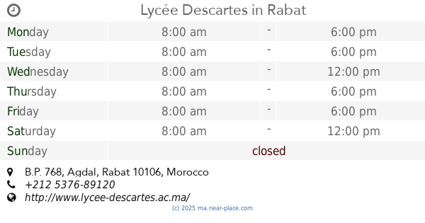
Lycée Descartes
B.P. 768, Agdal, Rabat
School
read more
971 m
School Taimount
16 Avenue Ibn Sina, Rabat
School
read more
📑
all categories
Accounting
Administrative area level 1
Administrative area level 2
Airport
Amusement park
Aquarium
Art gallery
Atm
Bakery
Bank
Bar
Beauty salon
Bicycle store
Book store
Bus station
Cafe
Campground
Car dealer
Car rental
Car repair
Car wash
Cemetery
Church
City hall
Clothing store
Colloquial area
Convenience store
Courthouse
Dentist
Department store
Doctor
Electrician
Electronics store
Embassy
Establishment
Finance
Fire station
Florist
Food
Funeral home
Furniture store
Gas station
General contractor
Grocery or supermarket
Gym
Hair care
Hardware store
Health
Home goods store
Hospital
Insurance agency
Jewelry store
Laundry
Lawyer
Library
Light rail station
Liquor store
Local government office
Locality
Locksmith
Lodging
Meal delivery
Meal takeaway
Mosque
Movie rental
Movie theater
Moving company
Museum
Natural feature
Neighborhood
Night club
Painter
Park
Parking
Pet store
Pharmacy
Physiotherapist
Place of worship
Plumber
Point of interest
Police
Post office
Premise
Real estate agency
Restaurant
Roofing contractor
Route
Rv park, camping
School
Shoe store
Shopping mall
Spa
Stadium
Storage
Store
Supermarket
Synagogue
Taxi stand
Train station
Travel agency
University
Veterinary care
Zoo
sublocality level 1
↑