School nearby المدرسة العليا للهندسة الداخلية
Morocco
School nearby المدرسة العليا للهندسة الداخلية
المدرسة العليا للهندسة الداخلية
Avenue Ahmed Balafrej, Rabat, MA Morocco
contacts phone
:
+212
Latitude:
33.9816796
, Longitude:
-6.8449372
larger map & directions
read more
nearest School
378 m
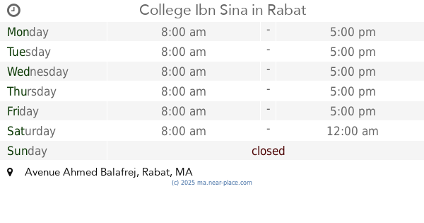
College Ibn Sina
Avenue Ahmed Balafrej, Rabat
School
read more
712 m
School Group Al Mouwatana
Avenue Ahmed Balafrej, Rabat
School
read more
734 m
Esai, Ecole Superieure d'architecture d'interieure
Rabat
School
read more
741 m
الحكامة و الاقتصاد
Rabat
School
read more
819 m
Morethanschool
Rabat
School
read more
827 m
Primary School Middle School Al Manbit
Angles Avenues Ahmed Rifai et Mehdi Benbarka, Rabat
School
read more
848 m
Al minbat ecole
Rabat
School
read more
867 m
Ecole Al Manbat
Rabat
School
read more
930 m
Acadomia : Numéro 1 Du Tutoring En France.
79 Avenue Ibn sina 1er etage, Rabat
School
read more
993 m
ACACIA FOOTBALL CLUB
Rabat
School
read more
994 m
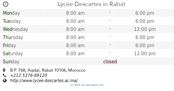
Lycée Descartes
B.P. 768, Agdal, Rabat
School
read more
1.001 km
School Taimount
16 Avenue Ibn Sina, Rabat
School
read more
1.174 km
Dgpc
Rabat
School
read more
1.208 km
Lycée Agricole
Rabat
School
read more
1.208 km
لالة عائشة الثانوية الإعدادية
Rabat
School
read more
1.231 km
Group Private School Les Quatre Temps
Hay riad,av al boustane,riad al andalous, Rabat
School
read more
1.337 km
CRECHE BABYCHOU
4, Rue Chafii, Rabat
School
read more
1.658 km
ILCS
Avenue Al Atlas, Rabat
School
read more
1.686 km
Madariss Assalam _ مدارس السلام
Rabat
School
read more
1.719 km
School Mohammed Ben Ahmed Chmaou
Rabat
School
read more
1.802 km
Argane Productions
Rabat
School
read more
1.823 km
Institut ITECH BTP
66 N°11, Rue Oued Moulouya, Rabat
School
read more
1.838 km
Smart Way
N° 6, Im 66, Avenue Fal Ould Oumeir, Rabat
School
read more
1.985 km
School Group Le Litoral Prive
Rue Chtouka, Rabat
School
read more
2.041 km
High Technology School in Morocco
Rue Chragas, Rabat
School
read more
📑
all categories
Accounting
Administrative area level 1
Administrative area level 2
Airport
Amusement park
Aquarium
Art gallery
Atm
Bakery
Bank
Bar
Beauty salon
Bicycle store
Book store
Bus station
Cafe
Campground
Car dealer
Car rental
Car repair
Car wash
Cemetery
Church
City hall
Clothing store
Colloquial area
Convenience store
Courthouse
Dentist
Department store
Doctor
Electrician
Electronics store
Embassy
Establishment
Finance
Fire station
Florist
Food
Funeral home
Furniture store
Gas station
General contractor
Grocery or supermarket
Gym
Hair care
Hardware store
Health
Home goods store
Hospital
Insurance agency
Jewelry store
Laundry
Lawyer
Library
Light rail station
Liquor store
Local government office
Locality
Locksmith
Lodging
Meal delivery
Meal takeaway
Mosque
Movie rental
Movie theater
Moving company
Museum
Natural feature
Neighborhood
Night club
Painter
Park
Parking
Pet store
Pharmacy
Physiotherapist
Place of worship
Plumber
Point of interest
Police
Post office
Premise
Real estate agency
Restaurant
Roofing contractor
Route
Rv park, camping
School
Shoe store
Shopping mall
Spa
Stadium
Storage
Store
Supermarket
Synagogue
Taxi stand
Train station
Travel agency
University
Veterinary care
Zoo
sublocality level 1
↑