School nearby Maplebear
Morocco
School nearby Maplebear
Maplebear
Rabat, Morocco
contacts phone
:
+212
website:
maplebearrabat.com
Latitude:
33.9711607
, Longitude:
-6.8620992
larger map & directions
read more
nearest School
114 m
High Technology School in Morocco
Rue Chragas, Rabat
School
read more
581 m
School Ibn al-Bashir
7 Avenue Al Haour, Rabat
School
read more
741 m
Group Private School Les Quatre Temps
Hay riad,av al boustane,riad al andalous, Rabat
School
read more
835 m
Ryad al Maarifa
Rabat
School
read more
1.134 km
لالة عائشة الثانوية الإعدادية
Rabat
School
read more
1.134 km
Lycée Agricole
Rabat
School
read more
1.134 km
مدرسة الجولان بالرباط
Rabat
School
read more
1.134 km
Ecole Qadi Ayad Primary
Rabat
School
read more
1.227 km
الحكامة و الاقتصاد
Rabat
School
read more
1.273 km
Les Grenadiers Crèche
Secteur 9, Rabat
School
read more
1.312 km
International School De Rabat Maternelle-Primaire
Rue Addalbout, Rabat
School
read more
1.364 km
KINDY CODE SCHOOL
38 Rue Attoute secteur 10 Hay Riad, Rabat
School
read more
1.768 km
Institut De Technologie Appliquee Yacoub El Mansour Rabat
Institut supérieure de technologie appliquée, Avenue Al Majd, Rabat
School
read more
1.898 km
Vision School Maroc
Avenue Abderrahim Bouabid, Secteur 17 D2 Hay Riad, Raba, Rabat
School
read more
1.919 km
School Mokhtar Jazoulit
Avenue Al Fath, Rabat
School
read more
1.996 km
Middle School Abdelaziz Dinia
Rabat
School
read more
2.082 km
Dgpc
Rabat
School
read more
2.121 km
Acadomia : Numéro 1 Du Tutoring En France.
79 Avenue Ibn sina 1er etage, Rabat
School
read more
2.127 km
Ccr Tutoring
Avenue Al Massira, Rabat
School
read more
2.153 km
Esint
kouass, Avenue Al Massira, Rabat
School
read more
2.18 km
école Al Maghrib Al Arabi
Rabat
School
read more
2.213 km
Performa Center
Avenue Azzaitoun, Rabat
School
read more
2.338 km
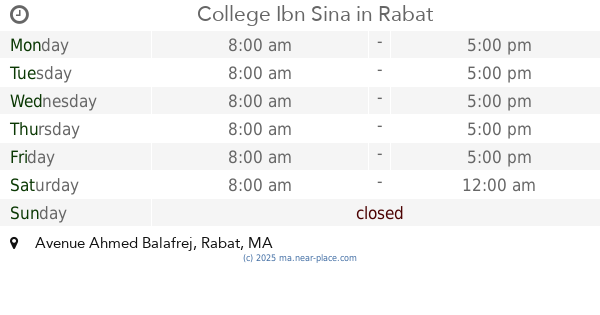
College Ibn Sina
Avenue Ahmed Balafrej, Rabat
School
read more
2.342 km
Morethanschool
Rabat
School
read more
2.561 km
école Abou Ouraïra
Rabat
School
read more
📑
all categories
Accounting
Administrative area level 1
Administrative area level 2
Airport
Amusement park
Aquarium
Art gallery
Atm
Bakery
Bank
Bar
Beauty salon
Bicycle store
Book store
Bus station
Cafe
Campground
Car dealer
Car rental
Car repair
Car wash
Cemetery
Church
City hall
Clothing store
Colloquial area
Convenience store
Courthouse
Dentist
Department store
Doctor
Electrician
Electronics store
Embassy
Establishment
Finance
Fire station
Florist
Food
Funeral home
Furniture store
Gas station
General contractor
Grocery or supermarket
Gym
Hair care
Hardware store
Health
Home goods store
Hospital
Insurance agency
Jewelry store
Laundry
Lawyer
Library
Light rail station
Liquor store
Local government office
Locality
Locksmith
Lodging
Meal delivery
Meal takeaway
Mosque
Movie rental
Movie theater
Moving company
Museum
Natural feature
Neighborhood
Night club
Painter
Park
Parking
Pet store
Pharmacy
Physiotherapist
Place of worship
Plumber
Point of interest
Police
Post office
Premise
Real estate agency
Restaurant
Roofing contractor
Route
Rv park, camping
School
Shoe store
Shopping mall
Spa
Stadium
Storage
Store
Supermarket
Synagogue
Taxi stand
Train station
Travel agency
University
Veterinary care
Zoo
sublocality level 1
↑