Local government office nearby Arrondissement dokkarat
Morocco
Local government office nearby Arrondissement dokkarat
Arrondissement dokkarat
Fes 30050, Morocco
contacts phone
:
+212
website:
agdal.fes.ma
Latitude:
34.0415821
, Longitude:
-5.0143659
larger map & directions
read more
nearest Local government office
526 m
Bureau Ozone Commune De Fes
Avenue Omar Ibnou Khattab, Fès
Local government office
read more
527 m
TLScontact Visa Application Centre for France - FES
Lot 4 lotissement Bel air, 3 Avenue Omar Ibnou Khattab, Champs de course, Fes
Local government office
read more
802 m
مجلس مدينة فاس
ملعب الخيل المدينة الجديدة فاس, Fes
Local government office
read more
812 m
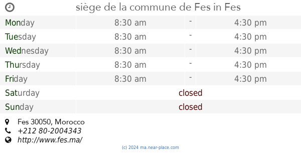
siège de la commune de Fes
Fes
Local government office
read more
51.186 km
Magasin ONE مخزن م.و.ك
Meknes
Local government office
read more
51.616 km
Maison De La Jeunesse
Hamria, Meknès
Local government office
read more
51.661 km
Regional Writing Justice and Development Party headquarters Meknes
Hamria, Meknès
Local government office
read more
51.751 km
PALAIS DE ViLLE
Hamria, Meknès
Local government office
read more
51.756 km
Croissant rouge marocaine
Boulevard Amir Moulay Abdallah, Meknès
Local government office
read more
51.849 km
Hôtel de la ville
Meknes
Local government office
read more
51.857 km
مندوبية التجارة والصناعة بمكناس
Rue du Ghana, Meknès
Local government office
read more
51.885 km
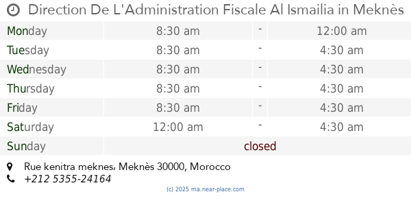
Direction De L'Administration Fiscale Al Ismailia
Rue kenitra meknes, Meknes
Local government office
read more
51.93 km
Sixteen administrative thereto
N13, Meknes
Local government office
read more
52.018 km
القباضة الإدارية للضرائب الإسماعلية
Rue Kenitra, Meknès
Local government office
read more
52.073 km
General management of taxes
Hamria, Meknès
Local government office
read more
📑
all categories
Accounting
Administrative area level 1
Administrative area level 2
Airport
Amusement park
Aquarium
Art gallery
Atm
Bakery
Bank
Bar
Beauty salon
Bicycle store
Book store
Bus station
Cafe
Campground
Car dealer
Car rental
Car repair
Car wash
Cemetery
Church
City hall
Clothing store
Colloquial area
Convenience store
Courthouse
Dentist
Department store
Doctor
Electrician
Electronics store
Embassy
Establishment
Finance
Fire station
Florist
Food
Funeral home
Furniture store
Gas station
General contractor
Grocery or supermarket
Gym
Hair care
Hardware store
Health
Home goods store
Hospital
Insurance agency
Jewelry store
Laundry
Lawyer
Library
Light rail station
Liquor store
Local government office
Locality
Locksmith
Lodging
Meal delivery
Meal takeaway
Mosque
Movie rental
Movie theater
Moving company
Museum
Natural feature
Neighborhood
Night club
Painter
Park
Parking
Pet store
Pharmacy
Physiotherapist
Place of worship
Plumber
Point of interest
Police
Post office
Premise
Real estate agency
Restaurant
Roofing contractor
Route
Rv park, camping
School
Shoe store
Shopping mall
Spa
Stadium
Storage
Store
Supermarket
Synagogue
Taxi stand
Train station
Travel agency
University
Veterinary care
Zoo
sublocality level 1
↑